ɸ-lab will welcome three visiting fellows from Airbus, joining a team working focused on the edge of disruptive technologies that monitor Earth’s environment from space. This is in line with one of ESA’s ɸ-lab goal: to help space researchers and companies to adopt these disruptive new technologies and methods.
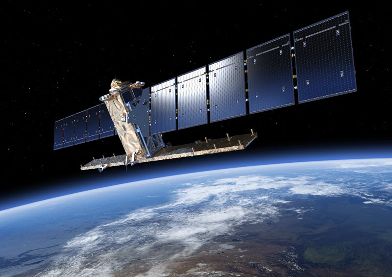
Copernicus programme, the largest single Earth Observation program to date is delivering an unprecedented wealth of data imagery. In fact, during the ESA Earth Observation Φ-week, the director of ESA Earth Observation programmes Josef Aschabacher, announced that Sentinel missions are delivering 150 TB of satellite data per day! Cloud computing platforms and Artificial Intelligence (AI) are overtaking traditional tools to tackle challenges coming from Big Data and extraction of meaningful information taking advantage of high revisit time provided by these missions.
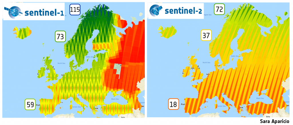
Data capture from Sentinel-1 (left) and Sentinel-2 (right) over summer 2018 during a three-month period (July-September). Number of passages increase with higher latitudes due to overlapping swaths.
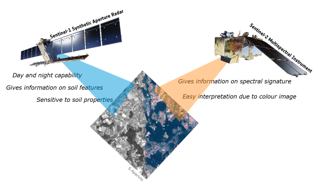
Research is underway to identify Machine Learning (ML) techniques for classification purposes fusing satellite data of different nature, namely synthetic aperture radar (SAR) and multispectral data from Sentinel-1 and Sentinel-2, respectively, from Copernicus program. Google Earth Engine provides many ML algorithms and satellite imagery data, being the method, which are very useful for extracting land cover from different sources of imagery. One of the main goals is to understand and quantify/qualify the improvement and accuracy of the best performing model (given by its overall accuracy) considering different bands and indices scenarios for multi-temporal land cover classification.
This will allow to create in a cost-effective way large-scale maps of land-cover at high resolutions, taking advantage of completely different type of sensors and higher revisit time from merging data from these constellations.
Do you want a career at the cutting edge of new space technologies? Have you expertise in artificial intelligence, small-sats, high altitude pseudo-satellites, computer science, distributed ledgers, quantum computing or the new space economy? Do you want to use your knowledge to make new earth observation and space systems? Do you want to work in a fast-paced environment where teamwork makes your ideas a reality in 2 or 3 months? Then apply today for current open positions at ESA’s Φ-lab (Frascati, Italy).
These posts are only open to nationals of ESA Member States or Cooperating States. The posts are in the Directorate of Earth Observation Programmes. ESA is an equal opportunity employer, committed to achieving diversity within the workforce and creating an inclusive working environment. Applications from women are encouraged, and priority is given to applicants from under-represented Member States. If you require support with your application due to a disability, please email contact.human.resources@esa.int.
Φ-lab Background
The Φ-lab’s mission is to accelerate the future of Earth Observation (EO), by helping Europe’s earth observation and space researchers and companies adopt disruptive technologies and methods. Right now, we’re working with Artificial Ingelligence (AI) on data from the Copernicus programme, Earth Explorer missions and cubesat satellites, drone and hyperspectral payload data and VR. HAPs, quantum technologies and distributed ledgers are on our to-do list. Φ-lab is part of the ESA Earth Observation Programme’s Φ-Department developing future systems for earth observation. Φ-lab also hosts ESA’s InCubed programme, providing rapid funding of innovative public private partnerships to exploit new EO markets. Φ-lab also convenes experts from across the World to develop research agendas on the relevance for EO of emerging technology topics including AI, distributed ledgers and quantum computing.
Archaeological Prospection using Crowdsourcing and Machine Learning
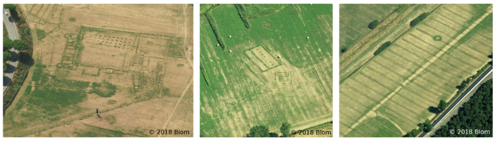
Research is underway on the combined use of crowdsourcing and machine learning with EO data to systematically detect buried archaeological structures. Crowdsourcing is initially used to create labelled data, taking advantage of human interpretation to identify, often very faint, archaeological crop patterns in remotely sensed imagery. This labelled data will then be used to train a convolutional neural network to systematically identify similar buried structures over a larger area.
Examples of Archaeological Residues in EO Data (click to enlarge the figure)
As the population of the Earth increases, so does the demand for resources. Development puts at risk the irreplaceable archaeological record. Especially in countries with a rich archaeological heritage, such as in the Mediterranean region, methodologies are sorely needed to increase the efficiency and reduce the costs of archaeological survey.
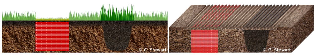
Crop Marks and Soil Marks (click to enlarge the figure)
At present, six countries have officially presented their AI strategy, as well as budget and scope. Finland, France, Germany, Italy, Sweden and the United Kingdom have announced investments ranging from € 200M for Finland to € 3B for Germany. All of them are planning, amongst others, to provide funding for new AI-dedicated laboratories and research institutes. Some have focused their strategy on specific sectors, such as Italy towards public services or France towards healthcare, transportation, environment and defence. Most of them also seek to attract AI investors to their country as well as to support the development and growth of innovative start-ups.
Although some countries do not have an AI strategy themselves, they have launched a comprehensive digital plan, in which the issue of AI is often discussed. This is particularly the case of Belgium, Denmark, Luxembourg and Spain.
The situation varies between different European countries, with some foreseeing the announcement of an AI-specific development plan (Estonia, Poland and Austria) while others rely more on the private sector in terms of R&D (Ireland, Netherlands, Norway and Switzerland).
The space sector was only explicitly mentioned in two of the AI strategies: that of France and Germany. The French Ministry of Defence have dedicated € 100M per year to AI (including space applications) while the UK will invest £ 93M into robotics and AI in extreme environments (including space).
French President Emmanuel Macron presenting the “AI for humanity” strategy at the AI Summit held at the College de France Research Centre
There is a need for higher level processing software of SAR datasets for developers that don’t have deep remote sensing or signal processing backgrounds to still do interesting geospatial analytics. ESA Φ-lab is addressing this issue by working on such a tool with ESA’s SNAP Toolbox under the hood.
Initially, the Open SAR Toolkit (OST) was developed at the Food and Agriculture Organization of the United Nations (FAO) under the SEPAL project (https://github.com/openforis/sepal). It has now been completely re-factored and transferred into a simpler and less-dependency rich python3 version.
OST automates the production of small to large-scale Sentinel-1 time-series and timescan data and therefore lowers the entry barrier for pre-processing of Sentinel-1 data. Jupyter notebooks are developed on top of this core package and should help to get started. The python package is available on our GitHub page (https://github.com/ESA-PhiLab/OpenSarToolkit) and can be easily installed using the python-3 pip package manger.
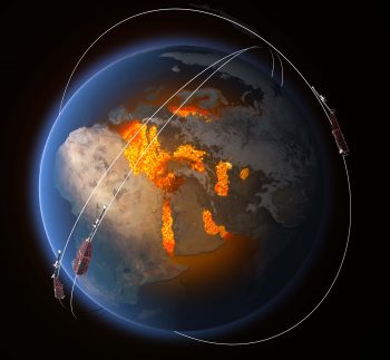
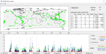
SWARM analysis using a data-driven approach Machine Learning
During a three month research sprint, an analysis of SWARM data was carried out to support existing activities which aim to identify possible earthquake precursors. To maintain an unbiased approach, unsupervised machine learning techniques were carried out to identify any possible correlations with earthquakes. In the timespan of the research activity it is has not yet been possible to confirm or deny the utility of SWARM data as earthquake precursors. However, a framework is being built which facilitates researchers to carry out similar, and more in-depth, analysis of multimission datasets, including SWARM, for precursor assessment of earthquakes and other phenomena, such as volcanic activity and lightning, using machine learning.
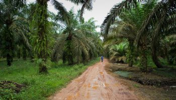
Palm oil is nowadays the most common vegetable oil used globally. As the demand grows, the expansion of palm oil plantations in the tropical regions will remain one of the main drivers of deforestation, having a considerable impact on biodiversity and disrupt the carbon cycle. Although the current hot spot of production is located in South-East Asia, future expansion is expected for African and South American tropical regions. The monitoring of its current extent and future expansion is crucial for validating the recent efforts towards a sustainable production on a global scale.
Palm oil plantation in Indonesia | Credit: Aul Rah
Φ-lab on mapping global palm plantations
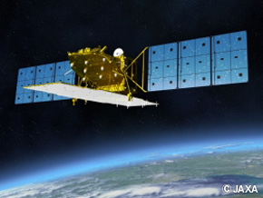
One of the main difficulties in mapping palm oil on a global scale is the regular cloud coverage over tropical regions and its spectral similarity to natural forests in the optical domain, which both hinders its applicability on a global scale. In this study taking part at Φ-lab, we overcome both limitations by using Sentinel-1 C-band SAR, ALOS-2 Palsar-2 L-Band SAR and SRTM elevation data. Traditionally L-Band SAR data is considered to be most efficient in mapping forested areas due to its long-wavelength signal that is capable of penetrating the canopy. In contrast, the strength of our method capitalises mainly on the dual-polarised VV/VH C-Band SAR data from Sentinel-1, which is particularly well suited to distinguish palm trees from other forest types.
Sentinel-1 C-Band SAR | Credit: ESAAlos-2 Palsar-2 L-Band SAR | Credit: EORC, JAXA
In addition, the 12-day revisit cycle of Sentinel-1 allows for the creation of dense time-series. The temporal behavior of the backscatter is then captured by using a timescan method, which depicts the usage of descriptive statistical parameters for every pixel in the full time-series. This helps in reducing the influence of environmental conditions and adds further strength in discriminating palm oil plantations. Simultaneously, the amount of data used for classification is reduced when compared to the full time-series and the number of input channels into the subsequent machine learning algorithm is standardized.
The drawback of this method is the huge amount of data pre-processing. To overcome this obstacle, we utilize the online platform Google Earth Engine that allows for the planetary-scale application of Earth Observation data.
How images of cats and dogs can help solving food security issues?
Current development in Artificial intelligence shows the strong ability of computers to learn information about our world. One of the most applicable methods artificial intelligence can offer is generalization of information based on some examples. These approaches applied to a certain problems resulted in a great success. For example, in computer vision domain, machines are now capable to classify any image into one of around a thousand of object categories with the accuracy comparable or even better than humans. The roots of the successful methods come from biomedical discoveries of how mammal brains analyse visual information.
This way is now being reflected in artificial intelligence by so-called deep learning. But our brain is capable to analyse not only images from our daily life environment, but also can recognize objects in satellite or drone images. So, why do not apply deep
learning techniques for Earth observation images? The only problem is that to achieve a good results, deep learning methods need a huge number of learning examples, which is typically not assured in Earth observations.
This is why Φ-lab is conducting a research on how methods and knowledge developed for computer vision can be transferred to Earth observation images via a process called transfer learning. Our first success was to show that general information learned by deep neural networks pre-trained on images of objects like cats and dogs can be very useful in crop types mapping on drone images.
Partnerships
This achievement is now being explored with our partners, World Food Programme and UNICEF Innovation for improving agricultural monitoring which helps manage food supplies and children’s welfare in developing countries.
Rohingya children playing at a UNICEF child friendly space. Credit : Anna Dubuis /DFIDComputer vision & Food security issues
Rohingya children playing at a UNICEF child friendly space. Credit : Anna Dubuis /DFIDComputer vision & Food security issues
This event was conceived during a mini-workshop on Quantum Computing for Earth Observation which was held on 15 November 2018 at the ESA Φ-Week in ESA’s ESRIN establishment in Frascati, Italy. At this event representatives from the quantum computing community, from both academia and industry, met with Earth Observation practitioners. The objective was to explore possible synergies between the two technologies to stimulate their further development and to accelerate their impact for societal benefit. The focus of the workshop was on the application of quantum computing for downstream data processing and Earth observation data exploitation.
The workshop aimed to prepare the ground for the opportunities that will be presented when the quantum community will be able to produce software for quantum-enhanced optimisation problems of direct use in big data management. Together with machine learning, quantum computing has the potential to be a game-changer in data science and applications.