Spotlight on climate and the New Space economy

Kicking off with a bold flourish, Φ-week 2021 promises to bring space even closer to the forefront of addressing society’s biggest challenges, namely issues associated with the climate crisis, while boosting the economy through transformative New Space, artificial intelligence, and quantum and cognitive computing.

ESA’s Φ-week is now in its fourth edition, and each year this forward-looking event is increasingly relevant to society, business and the economy.

In his opening address, Josef Aschbacher, ESA’s Director General said, “Europe faces unprecedented societal, economic, and security challenges. Space has enormous untapped potential to play in tackling pressing current and future crises, while simultaneously providing new impulse for the European space sector. We need to develop smart, automated services and applications to protect lives of people and to increase the protection of assets and natural resources.”

Read the full article on www.esa.int


Photo Copyright: Valentina Stefanelli

Watch live: ESA Φ-week

Focusing on the New Space economy and innovations in Earth observation, ESA’s fourth Φ-week kicks off on Monday 11 October. Join us live for two of the main sessions: the Opening session on Monday at 10:30 CEST and the Blending New Space Technologies and Services session on Tuesday at 16:00 CEST.

As the world starts to return to normality in the wake of the COVID pandemic, this year’s Φ-week is a hybrid event, with registered participants attending virtually and invited speakers present at ESA’s Centre for Earth Observation in Italy.

However, part of this not-to-be-missed event can be enjoyed by all – simply tune into ESA’s Web TV and following the live transmission links. 

Read the full article on www.esa.int

Mayday.ai develops its AI-automated platform under InCubed programme

Mayday.ai GmbH will launch a new AI-automated platform in Europe developed with the support of the ESA InCubed programme and the German Aerospace Centre (DLR) for its next-generation disaster and risk information services.

Mayday.ai GmbH will deliver a centralised and AI-based platform providing real time and near real time disaster and risk information services. This German-based start-up provides early warning and (geostationary, polar), camera imagery, audio as well as social media sentiment analysis.

The solution, which runs on an agnostic AI fusion engine, will be available for government agencies, international organisations, first responders, insurance and utility for up to 18 disaster types with native language support.

Mayday.ai’s proposal was selected under the ESA’s programme InCubed Investing in Industrial Innovation with the support of the German Aerospace Centre (DLR), and was kicked-off in July 2021.

The development aims at further enhancing Mayday.ai’s disaster management platform and adapting it to the European setting and its neighbouring regions. It also supports the development of additional disaster management products as well as accelerating Mayday.ai’s global expansion.

We are delighted that ESA and DLR have recognised our technological edge and potential, and grateful for their continuing support in our global growth out of Europe as we build our platform on the Sendai Framework principles. Our innovations will cater to the nuanced community needs globally, with the support of a community-owned model, as well as scenario-based automated notifications. Climate resiliency is within reach in case of many disasters with a culture shift towards proactive prevention, as opposed to the currently fragmented and highly reactive one. More importantly, in addition to saving lives, property, cultural and natural heritage, it also costs remarkably less to accomplish” states Mayday.ai’s Founder and CEO, Kian Mirshahi.

Bertrand Le Saux, ESA Technical Officer, added: “The Mayday.ai platform will provide a next-generation, centralised solution to organise a timely and coordinated response to natural hazards. It will leverage real-time satellite imagery and AI-enhanced predictive analytics to provide automated detection, early warning and integrated two-way communication services for various types of incidents.”

After a number of successful global pilots, the Mayday.ai team will be releasing its enterprise version of its platform in a partnership with Esri, the Environmental Systems Research Institute. In autumn 2021, the company aims to officially launch its efforts to boost community-based resiliency through various global campaigns.

More information on Mayday.ai GmbH InCubed activity can be found here.

Mayday.ai Real Time Disaster Information Web based Platform in Esri.

To know more: Resilient Europe 2.0, Mayday.ai, Mayday.ai Linkedin, German Aerospace Centre (DLR)

InCubed releases a dedicated call for Danish companies


Are you a Danish start-up or company working in Earth observation and using satellite data? Apply now for the InCubed Denmark call here. The deadline is 22 August.

InCubed stands for ‘Investing in Industrial Innovation’ and is a Public Private Partnership co-funding programme run by the ESA Φ-lab that focuses on developing innovative and commercially viable products and services that exploit the value of Earth observation imagery and datasets. InCubed has a very wide scope and can be used to co-fund anything from building satellites to ground applications and everything in between as well as the development of new EO business models.

The programme works in  very close cooperation with its participating Member States and can issue dedicated country-oriented calls as the one just published for Denmark.

In 2021, Danish companies and commercially focused research institutions can apply for up to 3.4 million Danish Kroner in co-funding for the development of innovative and commercially sustainable technology, products and services using Earth observation data through ESA’s InCubed programme.

The call and application form are available online on: link.

The deadline for submitting project pitches to ESA and the Danish Agency for Science and Higher Education is Sunday 22 August.

Idea pitches and proposals are assessed by the Danish Agency in an open competition, based on specific criteria including growth and competitiveness, level of innovation and societal impact. Once evaluated, successful applicants will receive a Letter of Support, which is required to finalize the application process with ESA.

Read more about the national process at the Danish Agency for Science and Higher Education website.


To know more: InCubed – How to Apply, Danish Agency for Science and Higher Education, UFM article promoting the call (in Danish)

Luxembourg-based company RSS-Hydro joins InCubed family

With a project called FloodSENS, the Luxembourg-based company RSS-Hydro is now part of ESA’s InCubed programme. The project aims to develop an algorithm that efficiently identifies flooded areas under partial cloud coverage in optical satellite images, using Machine Learning and auxiliary high-resolution data from drones, digital elevation models, as well as water flow algorithms.

Floods are one of the most devastating natural disasters, accounting for the highest insured and uninsured losses annually, as well as costing many lives. The climate emergency intensifies the hydrological cycle. Consequently, the frequency and magnitude of extreme hydro-meteorological events, and therefore the risk of floods, are increasing, as confirmed to be happening in many places around the world. This flooding increase has devastating consequences, among which are a greater strain on humanitarian response efforts and the financial risk of the global (re)insurance market.

With the support of ESA InCubed programme, RSS-Hydro has now started to work on FloodSENS, a service that specifically addresses these issues by developing a flood mapping application for the open market that overcomes one of the major limitations of optical EO imagery during floods and is capable of efficiently scaling between optical satellite and drone images. Therefore this novel application would be able to efficiently reconstruct flooded areas under partial cloud cover in optical satellite images.

Guy Schumann, RSS-Hydro CEO, said: “This type of application is especially important for disaster response agencies at regional, national, and international level, who are keen to utilize the proliferation of open satellite data for flood mapping during emergencies. Additionally, in the insurance and re-insurance markets, stakeholders are interested in EO data to map the flood hazard of a high-impact event and, on a historical basis, to understand risk exposure and the changing nature of it.”

Bertrand Le Saux, ESA InCubed Technical Officer, added: “FloodSENS integrates both drone data and EO imagery with Machine Learning, to offer the best support to emergency response activities, as well as to the re-insurance market. At ESA, we see a big potential in this activity and we are ready to support it until its entry into the market”.

For Europe, but also for many other countries worldwide, future innovative EO-based and Machine Learning-powered apps would add considerable benefits to the existing products and services of the free Copernicus Emergency Management Service (EMS) and beyond. RSS-Hydro’s FloodSENS will position itself at the intersection of these two fields (EO technologies and Machine Learning application tools) and at the forefront of future EO-enabled innovative solutions, enabling a much more effective disaster response.

More information on the FloodSENS InCubed activity can be found here.


Image caption: The first half of 2019 was a devastating period for many countries in southeast Africa. After Cyclone Idai destroyed many places, in particular the port city of Beira, at the start of the year, Cyclone Kenneth ravaged northern Mozambique. Entire villages were destroyed and almost one million people were put at risk in the area. This partial cloud-free subset of a Sentinel-2 image from 3 May 2019 shows large areas under water in Pemba, regional capital of Cabo Delgado state, which experienced over 2 m of rain and flooding. FloodSENS will render optical imagery like this more usable during floods by reconstructing flooded areas under cloudy skies.


Links: FloodSENS, RSS-Hydro, Company Linkedin

InCubed supports InfoSequia’s satellite-based Drought Early Warning and Forecasting System

ESA’s InCubed programme is supporting the development and pilot implementation of FutureWater’s new InfoSequia module, dubbed 4CAST. InfoSequia-4CAST combines historical and up-to-date observations of satellite-based meteorological and agricultural drought indices with climate variability indices to generate seasonal outlooks of water supply and crop yield failure alerts.

Water and food security are at risk in many places around the world, at present and even more so in the future, with significant economic and humanitarian consequences. Risk managers and decision-makers, such as water management authorities and humanitarian-aid agencies, can more effectively prevent harmful drought impacts if timely and actionable information is available on how water and food availability is affected.

FutureWater, a Dutch SME specialist in water management solutions, is developing InfoSequia-4CAST to provide users with timely predictions on drought impacts on crop yield and water supply. Seasonal outlooks are computed by a novel, state-of-the-art Machine Learning technique, previously  tested in applications for crop production forecasting and agricultural drought risk financing. The module responds to needs identified in previous applications and is a major extension of FutureWater’s Drought Early Warning and Forecasting System, InfoSequia. Another module, InfoSequia-MONITOR, is also being improved by incorporating satellite data to create multi-sensor drought indices.

Using multi-sensor, state-of-the art satellite data fully integrated with predictive models, InfoSequia-4CAST provides location-specific 3-6 month outlooks and warnings of crop yield and water supply failures to end users through a simple, intuitive user interface.

After signing  the contract with ESA in February 2021, FutureWater Project Manager Gijs Simons said: “This ESA supported InCubed activity is a unique opportunity for FutureWater to transfer a highly promising technology from the academic domain to a market-ready, operational decision-support tool. We are very enthusiastic about collaborating with ESA and a range of regional stakeholders to realise this product, which we believe can make a crucial difference for water management authorities and humanitarian NGOs worldwide.” 

FutureWater works with one of the world’s leading institutes in sustainability science, the Institute for Environmental Studies of the Free University of Amsterdam (IVM), to develop InfoSequia-4CAST. The product is targeted to the needs of water managers who intend to alleviate and mitigate the impacts of forthcoming drought periods by taking well-informed water management decisions, as well as humanitarian NGOs aiming to trigger ex-ante cash transfers with policyholders and farmer communities.

The InCubed activity includes collaborations with stakeholders and future end users in Spain, Colombia and Mozambique in order to establish user requirements, inform system design, and achieve pilot implementation of the system in the second project year.

Anna Burzykowska , ESA InCubed Technical Officer, added: ‘’The Earth Observation market sees an increased uptake of different type of products providing drought indices and early warning systems. The development of the FutureWater’s-4CAST module will enhance the current offering by producing advanced regional drought impact models with important improvements such as fusion with climate data records, yield forecasting as well as monthly and quarterly seasonal outlooks to more effectively manage the disaster impacts. We look forward to facilitating the project’s R&D activities as well as to supporting the engagement with new institutional and commercial customers.’’.

More information on the InfoSequia-4CAST InCubed activity can be found here.


To know more: FutureWater, InfoSequia-4CAST, InCubed activity, InfoSequia-MONITOR, IVM

The next ESA Norway Industry Day is coming

The ESA Φ-lab and the InCubed programme will be presented, together with the Norwegian ESA BIC and the ESA BASS programme, at the Norway Industry Day that will be held on Tuesday 11 May.

All Norwegian companies working in the Earth Observation value chain – from satellites, systems, sub-systems to ground segments and the utilisation of space applications – are welcome to participate in the next Norway Industry Day, which will take place virtually on Tuesday 11 May, starting at 10 CET until 13.00 CET.

Giuseppe Borghi, Head of the Φ-lab, and Amanda Regan, Head of  Φ-lab Invest Office, will give a general overview of the Φ-lab activities and opportunities and of the Investing in Industrial Innovation (InCubed) programme.

Rita Rinaldo, from the Downstream Business Applications Department of the Telecom and Integrated Applications Directorate,  will present the ESA BASS programme together with representatives from the Norwegian ESA BIC with company examples.

Presentations will focus on the Norwegian space economy perspective.

Representatives of companies that are already part of InCubed will provide their experience of working with the φ-lab and InCubed.

If your Norwegian company is interested in Earth observation and would like to attend the Industry Day, please contact Ville Meskus and Ole Morten Olsen.

The event will be held in English.


When: Tuesday 11 May 2021

Where: Online

Φ-lab and InCubed at the Earth Science Information Partners Innovation Webinar

The ESA Φ-lab and InCubed programme will be presented at the next Earth Science Information Partners Innovation (ESIP) Webinar to be held online on Wednesday 28 April, at 16:30 CEST.

The next Earth Science Information Partners Innovation Webinar will be organised in a virtual format next Wednesday 28 April, at 11:30. Registration are opened here.

The webinar shall focus on the φ-lab and Investing in Industrial Innovation (InCubed Programme)

InCubed is a 100M euro open-call programme that focuses on developing innovative and commercially viable products and services to leverage the value of Earth observation data. This programme has a very wide scope and can be used to co-fund anything from building satellites to ground applications and everything in between or to develop new EO business models.

During the webinar, the InCubed Programme manager Amanda Regan shall provide an overall of the φ-lab and the InCubed programme and four companies who are in the InCubed pipeline shall present their activities: Hyperscout-2, CoastEO, MANTIS, and SAT4FLOOD.

Registrations are opened here.

To know more about this event please visit www.esipfed.org


When: Wednesday 28 April 2021
Where: Online

SuperVision Earth becomes the first German company to perform InCubed work

SuperVision Earth is a German start-up established in 2018 by the winners of that year’s local Copernicus Hackathon. Since then, the start-up has benefited greatly from the Copernicus Accelerator, Copernicus Incubator and ESA BIC programmes. This latest InCubed activity will develop SuperVision Space, an automated satellite-based monitoring solution for routine pipeline monitoring.

More than a million kilometres of high pressure pipelines, often buried underground, run through countries supplying gas and energy to businesses and communities worldwide. The pipelines are subject to various risks, such as third-party activities, vegetation and ground movement. Third-party activities, such as construction or digging close to pipelines, are the leading cause of incidents. An early and efficient detection of risks is necessary to minimise environment exposure and damage, natural gas explosions, loss of lives and carbon emissions. In addition, it could also save gas companies millions.

To address this issue, SuperVision Earth developed SuperVision Space (SVS) based on proprietary AI-powered software to analyse satellite data, detect and regularly report on various risks. ESA’s InCubed programme will co-fund SVS, support its development, and de-risk the activity by providing technical and programmatic support. As part of the programme, SuperVision Earth will also gain access to potential investors and networking opportunities through dedicated events and possible arrangements being explored in 2021.

Alongside ESA’s InCubed programme, SuperVision Earth has partnered with the energy and infrastructure companies Entega and Terranets. These partners have already conducted several pilot projects in the field of satellite-based pipeline monitoring.

The InCubed contract was signed and the kick-off meeting took place end of March 2021, attended by SuperVision Earth, Entega and Terranets, alongside representatives from ESA. Members of the German delegation, who backed this activity were also in attendance, alongside representatives from the German industry association DVGW, a standardisation body for the gas and water industry, who are supporting SuperVision Earth with their expertise.

On signing the InCubed contract, SuperVision Earth’s COO and co-founder Jan Kolmas said: ‘’We are honoured to be the first German company to sign a contract with ESA’s InCubed programme. This activity is essential to SuperVision Earth’s mission of making gas infrastructure more secure, with a positive impact on the reduction of CO2 emissions, increased competitiveness of the European EO and AI sectors, and generation of high-tech jobs in Europe.’’

Left to right: Supervision Earth’s CEO Karsten Wiertz, CTO Sebastian Bussman, and COO Jan Kolmas

Satellite-based monitoring represents a useful addition to the toolbox of gas infrastructure operators, thanks to its low cost, its convenient frequency and its absence of carbon dioxide emissions. SuperVision Earth’s SVS downloads satellite images of pipeline corridors from providers around the world. These are analysed by an embedded AI model in order to detect potential threats. SVS then sends prompt warnings to the operator’s engineers, who use the product to make informed decisions, so preventing threats from becoming catastrophic incidents such as natural gas explosions, environmental damage and economic costs. More information on SVS can be found here.

Amanda Regan, InCubed programme manager, added: ‘’This activity offers an innovative solution aimed at gas and energy pipelines monitoring. This is the first German InCubed contract to be signed and we would like to thank both SuperVision Earth and the German Delegation. This is an innovative concept which will contribute to the overall European EO commercial landscape.’’


To know more: SuperVision Earth, InCubed activity, Entega, Terranets, DVGW

InCubed supports Satforcert for sustainable forest management

Irish company Treemetrics will work with ESA’s InCubed programme to develop Satforcert, a commercial platform to enable the delivery of forest certification and carbon verification standards. Satforcert leverages the latest satellite imagery from the Sentinel satellites and will make it easier for forest owners globally to adopt forest certification.

According to the World Bank (2015 report), global demand for wood is set to quadruple by 2050. The challenge now is to rapidly deploy forest certification standards to meet the exponential growth in demand for sustainable forest management practices and sustainably sourced forest-based products. 

Satforcert, developed by Irish company Treemetrics, aims to address these issues by developing an online platform providing tools to facilitate the forest certification process. The contract signing and kick-off meeting for this latest InCubed activity took place in November 2020. Satforcert will utilise the latest EO data by integrating satellite images (e.g. Sentinel-2), maps, documents, checklists, corrective actions, processes and reporting together into centralised systems replacing the many systems and spreadsheets currently used. This streamlined approach will enable more effective and transparent forest certification. More information can be found here.

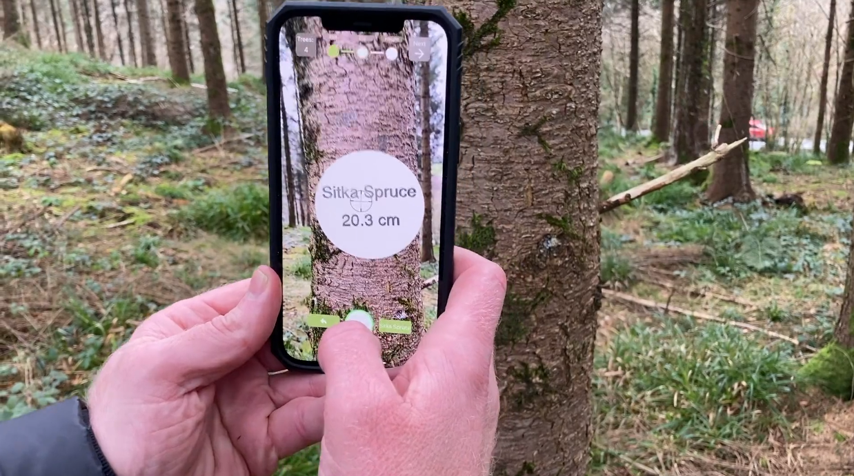
Treemetrics’ vision for the future is a digitised global forest industry that optimises productivity and sustainability through a move to precision forestry. The Irish company captures and analyses data using customised satellite and mobile communication’s technology to enable forest owners and managers to maximise sustainable production and profitability. The Irish company’s Forest HQ Cloud-based (SaaS) data platform integrates easily with all other systems used by clients and delivers real-time critical operational data to inform sustainable decision making. Treemetrics’ data insights are also integrated into stakeholders’ processes throughout the forest management and supply journey, ensuring better forecasting and optimising production.

Amanda Regan, ESA’s InCubed programme Manager, said: ‘’Satforcert is the latest InCubed activity to provide potential customers with sustainable decision making, and we look forward to working with Treemetrics and other companies to develop these kinds of technologies which are shaping the future of EO.’’

ESA InCubed, along with Enterprise Ireland, will support the development of Satforcert to enable the delivery of forest certification and carbon verification standards. Enda Keane, Treemetrics CEO and founder, welcomed the co-funded collaboration with ESA and forest industry partners commenting:

“Over the past 15 years Treemetrics, with the support of Enterprise Ireland, has worked in over 35 countries across the planet and we have observed the positive impact of responsible forest management. The global forest industry has a huge challenge to meet the growing demands for wood. We are delighted to be working with global leaders and look forward to delivering a system that makes forest certification easier to adopt and more transparent for auditing.”

Welcoming the announcement, Minister of State for Business, Employment and Retail, Damien English, TD, said: “Treemetrics are a fantastic example of an innovative Irish company using digital space data, made available through Ireland’s membership of ESA, to ensure the sustainability of raw materials on Earth.”

Satforcert will be developed in partnership with major players in sustainable forest management certification, including the Programme for the Endorsement of Forest Certification (PEFC) and the Sustainable Biomass Programme (SBP). PEFC is the world’s largest forest certification system, with 790 million acres of PEFC-certified forest across the globe, and will ensure Satforcert meets the needs of their international certificate holders. SBP, a global standard to ensure that wood biomass is sourced sustainably, will also support the development phase. 

Other partners include the leading forest auditing body Soil Association, which is responsible for the certification of 18 million hectares every year. F&W Forestry, the largest private forest manager in the UK, will also support the project to ensure the platform meets the needs of private forest owners and managers globally. These companies will bring a wealth of experience having pioneered the adoption and delivery of forest certification standards for the past two decades.

Satforcert will also provide carbon verification standards and be used by Forest Carbon who lead the way in UK woodland creation for carbon capture. Enda Keane, Treemetrics CEO and founder, added: “Forest Carbon is a rapidly emerging product that forest owners are monetising across the planet. The platform will also leverage the Treemetrics precision measurement, verification and certification tools that help to reduce the potential associated risk and increase overall adoption of this important mechanism.”


To Know more: Satforcert InCubed activity, Treemetrics, Enterprise Ireland, PEFC, SBP, Soil Association, F&W Forestry, Forest Carbon